The Overlay Layers tool combines two layers into a single layer using one of three methods: Intersect, Union, or Erase.
The output is a hosted feature layer.
Examples
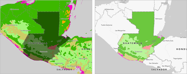
A field scientist requires a dataset showing the ecoregions in Guatemala, but only has access to a global layer. The Intersect overlay type in Overlay Layers can be used to clip the global layer to the Guatemala country boundaries.

Usage notes
Overlay Layers includes configurations for input features, overlay settings, and the result layer.
Input features
The Input features group includes the following parameters:
Input features is used to choose the point, line, or polygon layer that will be overlaid. The attributes from this layer are included in the output for all overlay types. You can choose a layer using the Layer button or use the Draw input features button to create a sketch layer to use as the input.
A count of features is displayed below the layer name. The count includes all features in the layer, except features that have been removed using a filter. Environment settings, such as Processing extent, are not reflected in the feature count.Overlay features is used to choose the point, line, or polygon layer to combine with the input layer. The attributes from this layer are included in the output if the overlay type is Intersect or Union. You can choose a layer using the Layer button or use the Draw input features button to create a sketch layer to use as the input.
A count of features is displayed below the layer name. The count includes all features in the layer, except features that have been removed using a filter. Environment settings, such as Processing extent, are not reflected in the feature count.
Overlay settings
The Overlay settings group includes the following parameters:
- Overlay type determines how the input layer and the overlay layer will be combined and which features will be kept. The following overlay types are available:
- Intersect—The input features are clipped using the overlay features. The features or portions of features in the input that overlap with the overlay features are kept. Intersect supports points, lines, and polygons as both the Input features and Overlay features.
- Union—The input and overlay polygons are combined. Union only supports polygons for both the Input features and Overlay features.
- Erase—The features or portions of features in the input layer that do not overlap with the features in the overlay layer are kept. Erase supports the following combinations of input layers:
Input features Overlay features Points
Points, lines, or polygons
Lines
Lines or polygons
Polygons
Polygons
- Output geometry determines the type of features (point, line, or polygon) created in the output feature layer. This parameter is available for the Intersect overlay type. The dimension of the output geometry type must be the same or less than both the input and overlay dimensions, where points=0 dimensions, lines=1 dimension, and polygons=2 dimensions.
Result layer
The Result layer group includes the following parameters:
- Output name determines the name of the layer that is created and added to the map. The name must be unique. If a layer with the same name already exists in your organization, the tool will fail and you will be prompted to use a different name.
- Save in folder specifies the name of a folder in My content where the result will be saved.
Environments
Analysis environment settings are additional parameters that affect a tool's results. You can access the tool's analysis environment settings from the Environment settings parameter group.
This tool honors the following analysis environments:
- Output coordinate system
- Processing extent
Note:
The default processing extent in Map Viewer is Full extent. This default is different from Map Viewer Classic in which Use current map extent is enabled by default.
Outputs
Overlay Layers creates an output hosted feature layer with point, line, or polygon features. The type of features created depends on the overlay method as follows:
- Intersect—The output geometry is the type specified in the Output geometry parameter.
- Union—The output geometry is polygons.
- Erase—The output geometry matches the geometry of the Input features parameter.
The output includes all attributes from both the input features and overlay features when the overlay type is Intersect or Union. The output only includes the attributes from the input features when the overlay type is Erase.
Licensing requirements
This tool requires the following licensing and configurations:
- Creator or GIS Professional user type
- Publisher or Administrator role, or an equivalent custom role
ArcGIS Server Advanced is required to enable Erase as an overlay type.
Resources
Use the following resources to learn more:
- Overlay Layers in ArcGIS REST API
- overlay_layers in ArcGIS API for Python
- Intersect in ArcGIS Pro
- Union in ArcGIS Pro
- Erase in ArcGIS Pro